
Proving rotation
- View
The technique that separates rotation from drift, the minimum time it takes, and why a photograph can never be a rotation report.
In this lesson you will
- Apply a fixed-reference-point method to assess apparent motion.
- State a minimum observation window before reporting rotation.
- Distinguish rotation from horizontal scud drift.
- Explain why time-lapse is a review tool and not a basis for a real-time report.
Pick something that cannot move
The eye is bad at this. A whole storm base translating across the sky, seen against nothing, reads as motion in whatever direction you were already expecting. The fix is to stop judging the cloud against itself and judge it against something fixed: a power pole, a tower, the corner of a roof, a tree on the horizon.
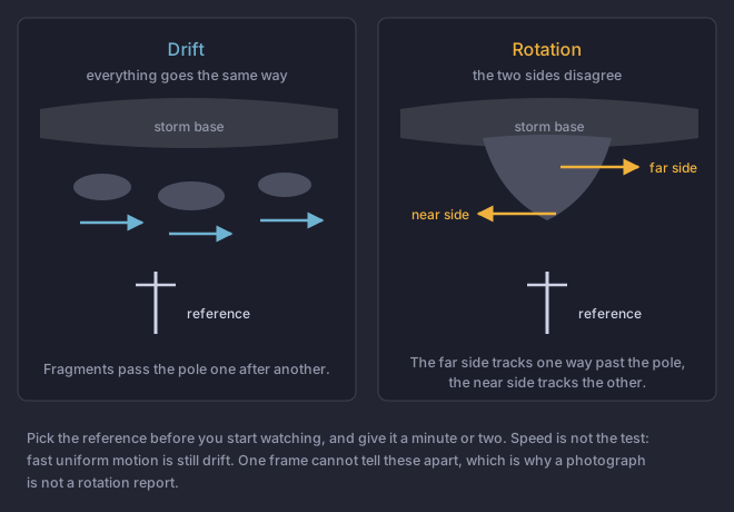
- Choose the reference before you start watching. Choosing it afterwards means choosing it to fit what you already believe.
- Watch for a full minute or two. Not a glance. Not one photograph.
- Look for the near and far sides disagreeing. A vertical-axis rotation seen from the side shows its far side tracking one way across your reference while its near side tracks the other. Everything traveling together is drift, however fast it looks.
- Look for convergence. Material tightening toward a single point, not just circling, is what distinguishes a developing funnel from a ragged base being blown along.
- Check it is still doing it. Persistence is the discriminator. One apparent turn is not a report.
How long is long enough
When viewing clouds like this, it is always best to stop and watch the feature for a minute or two. If the cloud is not rotating, it is not a tornado or a funnel cloud.
A minute or two feels like a long time with a storm in front of you, and it is the difference between a report an office trusts and one that costs your network credibility. The Field Guide's instruction when you are unsure is simply to continue to observe the feature. There is no shame in a delayed report; there is real cost to a wrong immediate one.
What a camera cannot do
A still photograph contains no motion, so it cannot show rotation. It can show a shape that a person then describes as rotating, which is not the same thing and is how a great many bad reports get corroborated after the fact.
Time-lapse is genuinely useful and genuinely misleading. Speeding footage up reveals rotation the eye misses in real time, which makes it a good review tool for learning what you missed. It is not a basis for a live report, because by the time you have shot and played back a sequence, the report is late and the office needed it during the warning.
The output of this technique is one of three sentences: rotation present, no rotation observed, or still watching. All three are useful to an office. Only the first two are commonly said, and the third is often the honest one.
Check yourself
A ragged lowering is moving quickly across the sky. Every part of it, near side and far, travels left to right at about the same speed. Rotation?
- No. Uniform motion in one direction is drift, however fast it looks
- Yes, if the motion is fast enough to be obvious
- Yes, because the whole feature is clearly in motion
- Cannot be determined without a photograph for comparison
Hint
Rotation requires two parts of a feature to disagree about which way to go.
Answer
No. Uniform motion in one direction is drift, however fast it looks
Everything going the same way is translation, not rotation, and speed has nothing to do with it. Rotation shows as the far side of the feature tracking opposite to the near side against a fixed reference, with material converging toward a point. This is the single most common misjudgment the technique exists to prevent.
Sources
- NWS Northern Indiana, "Low hanging clouds mistaken for Funnel Clouds and Tornadoes"
- NWS Weather Spotter's Field Guide (YPA-201154, June 2011)
- Branick, A Comprehensive Glossary of Weather Terms for Storm Spotters, NOAA Technical Memorandum NWS SR-145